Local Attractions & Historical Sites
Church of God founding site
Church of God Site – Where it all began.
The date 1881 is carved on the rock cliff one mile north of Highway 68 on Barney Creek which marks the
location of the building in which Christian Union was organized by Rev. Richard G. Spurling, Sr. Following his
fathers death, Richard Spurling, Jr. continued as leader and in 1902, Christian Union was renamed as Holiness
Church of Camp Creek. In 1907 the church officially adopted the name Church of God. You can see a carving
that reads “1881 This date was carved by Richard Spurling, Jr. When foundation of the building was laid,
where Christian Union was in 1886. The Church was called Holiness Church of Camp Creek. 1902 in the home
of W. S. Bryant, and later interpreted as Church of God in 1907 at Cleveland, Tennessee.”
Ironsburg Cemetery
Several Civil War grave sites can be found in this cemetery.
Wococee Indian Village
Cherokee Indians populated this 100 acres along Coker Creek. This area was one of the largest villages in the
country. It is possible that DeSoto in 1540 was the first white man to see this southern Appalachian region.
The first white comers found the Cherokee Indians occupying the land. These Indians lived in permanent
villages and grew corn, pumpkins and other crops. Their capital, Talicuo was about a mile east of the town of
Tellico Plains and the site of Wococee Village is approximately twelve miles from the Indian capital and can
still be seen along coco creek, now known as Coker Creek. The Indians began to fear the gold they had in their
streams because it was one of the reasons they were eventually forced from their homeland in the azure hill to
the dusty plains of Oklahoma.
CCC Camp near Coker Creek
CCC (Civilian Conservation Corp) Camp Rolling Stone #1454 on Joe Brown Highway
In 1933 Franklin D Roosevelt and the democratic party searching for an end to rampant unemployment and
economic chaos initiated the Civilian Conservation Corps. He planned a fight against soil erosion and declining
timber resources by utilizing the unemployed of large urban areas. President Roosevelt revitalized the faith of
the nation with several measures, one of which was the Emergency Conservation Work Act, more commonly
known as the Civiliam Conservation Corps. With this action he brought together two wasted resources, (1) the
unemployed young men of America and (2) the land, in an effort to save both.
Each member had to send home $25.00 of his $30.00/ month salary. These men lived in tents and in some
areas of the country, built dormitory cabins which evolved into temporary little towns. At one time almost
600,000 men worked in the CCC called “Roosevelt’s Tree Army.” Camp Rolling Stone still has a few remnants
of what once kept many American families from incredible suffering.
Old Tollgate Site
A toll was charged for the use of the Turnpike for the passage of any “person or thing”. “For every man and
horse, twelve and one-half cents; for every lead horse not in a drove, six and one-fourth cents, for every loose
horse in a drove, four cents; for every foot man, six and one-fourth cents; etc. The Turnpike Company was
originally chartered for a period of 20 years and was of great utility to Knox and surrounding counties in the
transportation of livestock, goods and persons to Charleston, South Carolina. Its greatest value to the people
west of the Alleghenies was in their ability to market livestock.
Doc Rogers Fields
A beautiful camping and horseback riding area in the Cherokee National Forest. This site has a beautiful view
of the mountains and Coker Creek runs through the fields as well as the Unicoi Turnpike and Trail of Tears.
Coker Creek Cemetery
Stop by and see markers dating back to the 1700s – See if you can spot the marker that says “Jim Morrow
Bushwhacked While Cradling Oats”
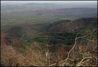
Waucheesi Overlook
Waucheesi OverlookFormer U.S. Forest Service lookout tower. Fantastic scenery and a great place to
photograph with its panoramic view. Watch the sunrise and sunset for breath taking views.
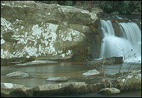
Coker Creek Falls
An amazing series of cascading walls of water provides a great place to wade, swim and have a great picnic.
You can hike the three mile trail along the creek and enjoy the beautiful scenery. There are lots of varieties of
trees and flowers to enjoy. The forest provides an umbrella over a walk in paradise. The great Cherokee
Warrior, Coqua is said to have visited the falls, stand on the side of the mountain & shout out a message,
whatever he asked for would return on his echo.
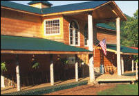
Coker Creek Village
The heart of the Coker Creek Community focuses on Coker Creek Village, the old Tellico Mountain Camp. Coker
Creek Village is completely equipped to house and entertain groups as small as 8 people up into the hundreds.
For the finest in get-a-way locations for your church group consider Coker Creek Village in the heart of Coker
Creek Community. web: www.cokercreekvillage.com
Buck Bald
Unbelievable panoramic views overlooking a three state area, Tennessee, Georgia and North Carolina. Hike or
ride up the six miles of mountain to get to the top which has a great little picnic area and a great spot for
Frisbee throwing.
Coker Creek Gold Panning
Gold was discovered in Coker Creek in the early 1830s. Most of the gold taken in the early days was from
Coker Creek and Cooper Holler. You can pan for Gold in any of the waterways in the National Forest and may
make enough to pay for your panning equipment or lunch. Coker Creek Gold has been written up in USA Today
and can be seen on TV Programs throughout the year. A local Chapter of the Gold Panning Association of
American can be contacted for local information if you want to try your hand at “striking it rich.”
The Coker Creek Welcome Center is a dealer for the Gold Panning Association of America, with Memberships
available at our location. We sell maps, books, panning supplies and make a free map and information
available.
Dawn at Unicoi Gap
Historic pass in the Unaka Mountain Range. Located on the NC/TN state line, through this gap passed Indian
trails connecting the towns of the lower, middle and Overhill Cherokees over which men and guns for manning
Fort Loudon passed. Through Unicoi Gap, 2 1/2 miles from Coker Creek, passed an old Indian trade path from
Chota, in Tennessee, by way of Tellico Plains and Coker Creek.
The Cherohala Skyway Visitor Center in Tellico Plains
Is a “must stop” before starting up the Skyway. Stop by for free maps of the Skyway and the Cherokee
National Forest, Skyway driving conditions and local area souvenirs and gifts. Picnic tables and spotless
restrooms are available. Our friendly staff will welcome you with important Skyway and area information! Call
423-253-8010 or visit http://cherohala.org/visitorcenter.html.
The Cherohala Skyway
Crosses through the Cherokee National Forest in Tennessee and the Nantahala National Forest in North
Carolina. The Skyway connects Tellico Plains, Tennessee, with Robbinsville, North Carolina. It is a wide,
paved, 2-lane road with sweeping curves and incredible mountain views. Visit http://www.cherohala.org.
Tellico Plains
Look at the foot of the Cherokee National Forest in East Tennessee, Tellico Plains is the perfect rural
community. People come to visit, love the “vintage Mountain Town” with all the shops and recreation,
and only too soon become residents that preserve the natural beauty they have come to appreciate. The town
square is filled with unique arts and craft shops, eateries, and a brick oven bakery. Tellico Plains is home to
the largest covered bridge in Tennessee. There is no better entrance to the pleasure of Cherohala Skyway than
a stop in Tellico Plains.
Tennessee Overhill Heritage Assoication Tourism Information
Offering free information to visitors and locals alike. Printed materials include a full-color Vistitor’s Guide,
Attractions Map, AgriCulture-a guide to local agri-tourism sites, Furs to factories Heritage Trail- a guide to
museums and historic sites, Unicoi Turnpike Trail- guide to trade path which predates written history and was
used by Indians, fur traders, European explorers, British soldiers, and livestock drovers, Forest Inspirations:
With these hands- a guide to local handmade arts, crafts, galleries, and places to find your own inspiration, as
well as other brochures to help you find information on Lodging, Outdoor Recreation, Biking, Birding, and
Events.
The Tennessee Overhill Heritage Association is a non-profit cultural and heritage tourism organization. The
Tennessee Overhill is comprised of the Southeast Tennessee Counties of McMinn, Monroe, and Polk, as well as
the southern portion of the Cherokee National Forest. Our mission is to promote and preserve the natural,
cultural, and historical character of the Tennessee Overhill through cultural tourism.
Tennessee Overhill
P. O. Box 143
Etowah, TN 37331
Email: office@tennesseeoverhill.com
Phone: 423-263-7232 or toll free 1-877-510-5765
Website: www.tennesseeoverhill.com